Reliable Drone Services for Construction, Agriculture, and Environmental Monitoring
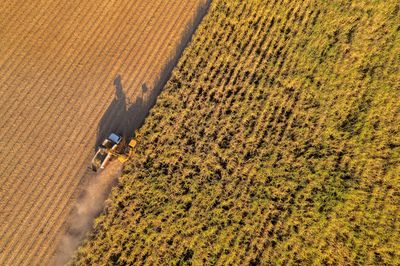
Precision Agriculture
Utilize high-resolution and advanced sensor data for environmental monitoring to monitor crop health, identify stress, assess irrigation efficiency, and enhance yield optimization within the framework of precision agriculture, similar to construction monitoring practices.
Construction Progress Monitoring
Track project progress through construction monitoring, document milestones, and provide visual updates to enhance planning, communication, and accountability, while also considering environmental monitoring and its role in precision agriculture.
Mapping & Surveying
Create accurate orthomosaic maps, topographic models, and measurements to support construction monitoring, environmental monitoring, and precision agriculture in planning, land assessment, and development projects.
Inspections
Inspect roofs, towers, structures, utilities, and hard-to-reach assets safely and efficiently through construction monitoring and environmental monitoring techniques, eliminating the need for scaffolding or shutdowns.
Volumetric Measurements
Quickly and accurately measure stockpiles, excavation volumes, and material quantities for construction monitoring, while also supporting environmental monitoring and precision agriculture initiatives in construction and aggregate operations.
Emergency & Public Safety Support
Provide aerial situational awareness, search assistance, and damage assessment, alongside real-time visual support for emergency response operations, while also enhancing construction monitoring, environmental monitoring, and precision agriculture efforts.
Environmental Monitoring
Assess land conditions, monitor vegetation health, analyze drainage patterns, evaluate erosion, and track environmental changes over time as part of construction monitoring and environmental monitoring practices in precision agriculture.
Aerial Photography & Videography
Capture professional-quality aerial images and video for construction monitoring, environmental monitoring, precision agriculture, documentation, marketing, inspections, and reporting.
Thermal Imaging
Identify heat loss, moisture intrusion, equipment issues, and anomalies for buildings and infrastructure through effective construction monitoring and environmental monitoring, especially in emergency scenarios.
Custom Drone Solutions
Tailored drone operations designed to meet specific project goals in any industry, including construction monitoring, environmental monitoring, and precision agriculture.